
INFRASTRUCTURE
Rozelle Interchange
In 2025, the Rozelle Interchange received the prestigious Urban Design Built Outcomes Award jointly from the Australian Institute of Architects, the Australian Institute of Landscape Architects, and the Planning Institute of Australia. The award recognised the project’s outstanding contribution to public space and community connection in Sydney’s inner west.
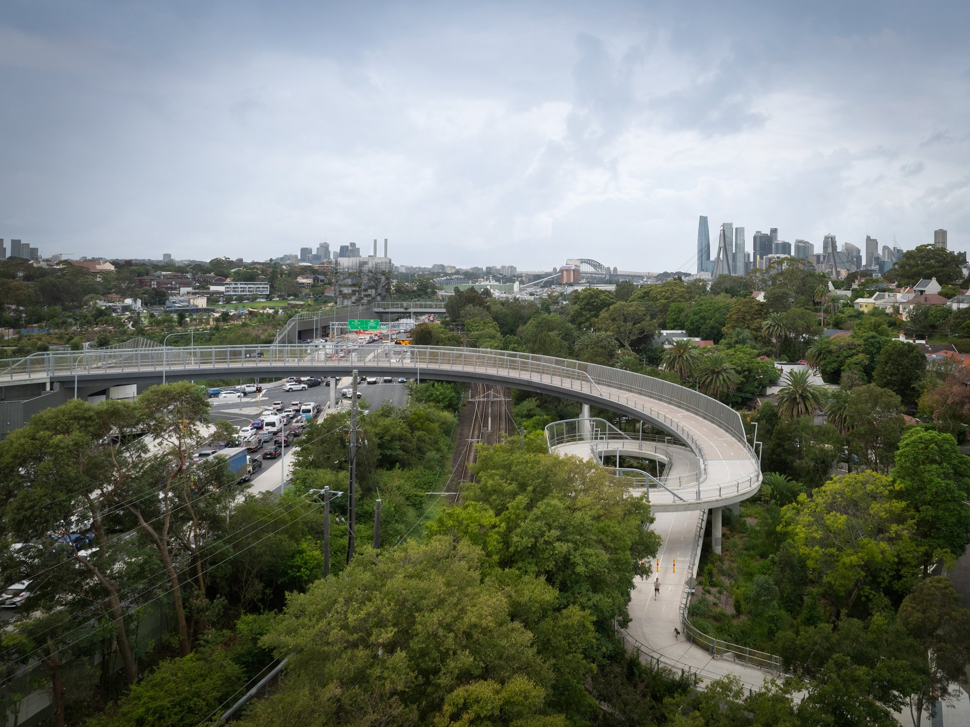
The judges praised the project for turning a complex infrastructure challenge into a valuable public asset. The Rozelle Parklands, created as part of the interchange, transformed a former industrial site into nine hectares of recreational space. This new parkland reconnects the suburbs of Annandale and Rozelle, areas divided for over a century by roads, railways, and industrial development.
The Rozelle Interchange was delivered by Transport for New South Wales and built by the John Holland CPB Contractors Joint Venture. The design team included Studio Colin Polwarth (SCP urban design) with Willow, HASSELL (landscape and lead design), Studio Chris Fox (ventilation station art installation), and WSP Arcadis Joint Venture (engineering).
Key Features
Underground Motorways: Most of the interchange is located underground, reducing surface disruption and freeing up land for public use.
New Parklands: Over nine hectares of recreational space is created between Rozelle and Annandale, offering recreational areas and natural landscapes.
Bridges for People: Four new pedestrian and cycling bridges reconnect communities across busy roads and rail lines. The bridges were designed by SCP.
Innovative Road Bridges: Two major road bridges were also built, including The Crescent Bridge—the first of its kind in NSW, designed to offer scenic views of Rozelle Bay and the city designed by SCP.
Landscaped Landbridge: A standout feature is the landbridge that links Rozelle Bay Light Rail Station to the new parklands. Hassell designed the landscape of the bridge. It provides safe, accessible passage for all users, including people with disabilities, cyclists, and pedestrians, designed by SCP.
Ventilation Towers as Art: Studio Chris Fox designed the ventilation towers as sculptural elements that blend into the landscape.
Integrated Design: HASSELL designed the parklands, tunnel interiors, and canal bridges, while Studio Colin Polwarth and Willow designed the architectural elements, including the motorway control centre and tunnel portals.
Reconnecting Communities
For decades, Rozelle and Annandale were separated by major infrastructure. The new landbridge and parklands now reconnect these neighbourhoods, offering a safe and scenic route for walking, cycling, and public transport. The landbridge encourages people to use the light rail, reducing car use and easing traffic congestion.
The landbridge was carefully designed to offer views of the city by subtly raising its height and lowering the adjacent road bridge. The Crescent Road Bridge, an engineering first in New South Wales, was built using a complex method that took over a year to design and construct.
Design and Community Impact
All bridges and structures were designed with organic shapes to blend into the natural surroundings by SCP. The tunnel entrances were kept simple and elegant, while the ventilation towers and buildings used natural materials and climbing plants to soften their appearance, by SCP.
The motorway control centre was built below ground level to reduce its visual impact. Its design by SCP continues the theme of simplicity and unity between architecture and landscape.
This project is one of the largest urban design and infrastructure efforts in Australia. It involved hundreds of professionals, including architects, engineers, landscape designers, Aboriginal advisors, and environmental specialists. The design process included community consultation and was guided by strict government approval conditions to ensure long-term quality and community benefit.
A Lasting Legacy
The Rozelle Interchange is more than just a road project—it’s a new ‘recreational heart’ for Sydney’s inner west. It returns valuable land to the public, improves transport connections, and creates a welcoming space for people and nature. The project stands as a model for how infrastructure can serve both functional and community needs.
Photographs and videos of the completed project, including aerial views, were captured by Ruth Gold in 2025 and are credited to Studio Colin Polwarth.